Geography - Class 9
Contemporary India-I
Chapter 2: Physical Feature of India
Question 1:Choose the right answer from the four alternatives given below.
(i) A landmass bounded by sea on three sides is referred to as
(a) Coast
(b) Island
(c) Peninsula
(d) None of the above
(ii) Mountain ranges in the eastern part of India forming its boundary with Myanmar are collectively called
(a) Himachal
(b) Uttarakhand
(c) Purvachal
(d) None of the above
(iii) The western coastal strip, south of Goa is referred to as
(a) Coromandel
(b) Konkan
(c) Kannad
(d) Northern Circar
(iv) The highest peak in the Eastern Ghats is
(a) Anai Mudi
(b) Kanchenjunga
(c) Mahendragiri
(d) Khasi
Answers :(i) (c) Peninsula
(ii) (c) Purvachal
(iii) (c) Kannad
(iv) (c) Mahendragiri
Question 2:Answer the following questions briefly
(i) What is the bhabar?
Answer :It is one of the four regions of the northern plains, which is formed when rivers come down from the mountains, deposit pebbles in a narrow belt of about 8 to 16 km in width lying parallel to the slopes of the Shiwaliks.
(ii) Name the three major divisions of the Himalayas from north to south.
Answer :The three major divisions of the Himalayas from north to South are:
- The northern-most range is known as the Great or Inner Himalayas or the Himadri with an average height of 6,000 meters.
- The second range is known as Himachal or lesser Himalaya. The altitude varies between 3,700 and 4,500 meters and the average width is of 50 Km.
- The outer-most range of the Himalayas is called the Shiwaliks. They extend over a width of 10-50 Km and have an altitude varying between 900 and 1100 meters.
(iii) Which plateau lies between the Aravali and the Vindhyan ranges?
Answer : Malwa plateau lies between the Aravali and the Vindhyan ranges.
(iv) Name the island group of India having coral origin.
Answer :Lakshadweep islands are the island group of India having coral origin.
Question 3:Distinguish between
(i) Bhangar and Khadar
| Bhangar | Khadar |
|---|---|
| It is an old alluvial soil. | It is a new alluvial soil. |
| It has high concentration of Kankar nodules. | it has low concentration of Kankar nodules. |
| it is infertile. | it is more fertile. |
(ii) Western Ghats and Eastern Ghats
| Western Ghat | Eastern Ghat |
|---|---|
| They are continuous and can be crossed through passes only. | They are discontinuous and irregular and dissected by rivers draining into Bay of Bengal. |
| Average height of Western Ghats is 900 - 1600 meters | Average height of eastern ghats is 600 meters. |
| Highest peak of western ghat is Anaimudi (2695m) and Doddabetta (2637m) | highest peak of eastern ghat is Mahendragiri (1501m) |
Question 4:Which are the major physiographic divisions of India? Contrast the relief of the Himalayan region with that of the Peninsular plateau.
Answer :The major physiographic divisions of India are:
(1) The Himalayan Mountains
(2) The Northern Plains
(3) The Peninsular Plateau
(4) The Indian Desert
(5) The Coastal Plains
(6) The Islands
Question 4:Contrast between Himalayan region and Peninsular Plateau:
Answer :| Himalayan Region | Peninsular Plateau |
|---|---|
| It is formed due to the collision of the Indo-Australian and Eurasian plates. | It is formed due to the breaking and drifting of the Gondwana land. |
| It consists of the loftiest mountains and deep valleys | It consists of broad and shallow valleys and rounded hills. |
| It is formed at the edge of the Indo-Gangetic plain. | It is formed at the edge of the Deccan Plateau. |
| The Himalayan region contains only a few minerals. | The Peninsular Plateau is the storehouse of the minerals. |
| The rivers that originate from the Himalayas are perennial | The rivers that originate from plateau are seasonal in nature. |
Question 5:Give an account of the Northern Plains of India.
Answer :The northern plain has been formed by three major river systems, namely — the Indus, the Ganga and the Brahmaputra along with their tributaries. This plain is formed of alluvial soil. The deposition of alluvium in a vast basin lying at the foothills of the Himalaya over millions of years, formed this fertile plain. It spreads over an area of 7 lakh sq. km. The plain being about 2400 km long and 240 to 320 km broad, is a densely populated physiographic division. With a rich soil cover combined with adequate water supply and favourable climate it is agriculturally a productive part of India.
Question 6:Write short notes on the following.
(i) The Indian Desert
Answer :The Indian desert lies towards the western margins of the Aravali Hills. It is an undulating sandy plain covered with sand dunes. This region receives very low rainfall below 150 mm per year. It has arid climate with low vegetation cover. Streams appear during the rainy season. But they disappear very soon into the sand as they do not have enough water to reach the sea. Luni is the only large river in this region.
(ii) The Central Highlands
Answer :The part of the Peninsular plateau lying to the north of the Narmada river, covering a major area of the Malwa plateau, is known as the Central Highlands. The Vindhyan range is bounded by the Satpura range on the south and the Aravali on the northwest. The further westward extension gradually merges with the sandy and rocky desert of Rajasthan. The rivers that flows in this region are Chambal, the Sind, the Betwa and the Ken from southwest to northeast, thus indicating the slope. The Central Highlands are wider in the west but narrower in the east. The eastward extensions of this plateau are locally known as the Bundelkhand and Baghelkhand.
(iii) The Island groups of India
Answer :The islands groups of India have two major islands: The Lakshadweep islands and the Andaman and Nicobar Islands group.
The Lakshadweep Island group lying close to the Malabar coast of Kerala. This group of islands is composed of small coral islands. Earlier they were known as Laccadive, Minicoy and Amindive. In 1973, these were named as Lakshadweep. It covers small area of 32 sq km. Kavaratti island is the administrative headquarters of Lakshadweep. This island group has great diversity of flora and fauna. The Pitti island, which is uninhabited, has a bird sanctuary.
The elongated chain of islands located in the Bay of Bengal extending from north to south are Andaman and Nicobar Islands. They are bigger in size and are more numerous and scattered. The entire group of islands is divided into two broad categories – The Andaman in the north and the Nicobar in the south. It is believed that these islands are an elevated portion of submarine mountains. These island groups are of great strategic importance for the country. There is great diversity of flora and fauna in this group of islands too. These islands lie close to equator and experience equatorial climate and has thick forest cover.
MAP SKILLS
Question :On an outline map of India show the following.
(i)Mountain and hill ranges – the Karakoram, the Zaskar, the Patkai Bum,
the Jaintia, the Vindhya range, the Aravali, and the Cardamom hills.
(ii)Peaks – K2, Kanchenjunga, Nanga Parbat and the Anai Mudi.
(iii)Plateaus, Chotanagpur and Malwa
(iv)The Indian Desert, Western Ghats, Lakshadweep Islands
Answer :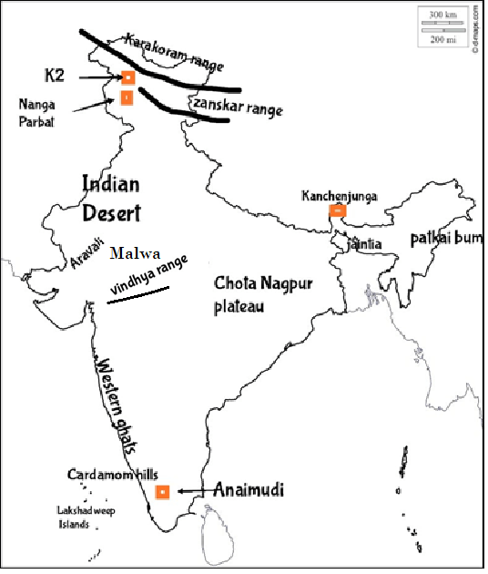
PROJECT/ACTIVITY
Question :Locate the peaks, passes, ranges, plateaus, hills, and duns hidden in the puzzle. Try to find where these features are located. You may start your search horizontally, vertically or diagonally.
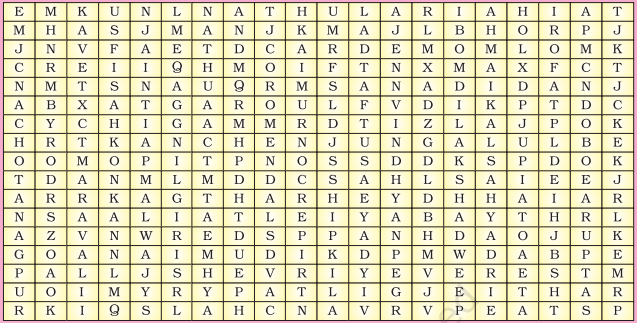
Vertical:
Chotanagpur- plateau in eastern India, in northwestern Chhattisgarh and central Jharkhand.
Aravali- Rajasthan
Konkan- Maharashtra
Jaintia- Meghalaya
Malwa- Madhya Pradesh
Nilgiri- Tamil Nadu
Shipkila- Himachal Pradesh
Vindhya- Madhya Pradesh
Bomdila- Arunachal Pradesh
Sahyadri- Maharashtra and Karnataka
Satpura- Madhya Pradesh
Horizontal:
Nathula- Sikkim
Cardemom- Kerala
Garo- Meghalaya
Kanchenjunga- Sikkim
Anaimudi- Kerala
Everest- between Nepal and Tibet, an autonomous region of China.
Patli- Uttrakhand
Answer :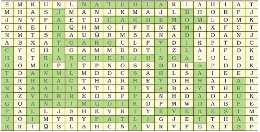
Intext Questions :
Question :The names of the glaciers and passes that lie in the Great Himalayas.
Answer :Glaciers in the great Himalayas : Gangotri, Chaturangi, Bhagirathi, Kharak, Satopanth, kamet,Milam and Pindari.Passes in the Great Himalayas : Karakoram pass, ShipkiLa pass ,Bomdila pass , NathuLa pass
Question :The name of the states where the highest peaks are located.
Answer :- Kanchenjunga in Sikkim
- Nanga parbat in Jammu & Kashmir
- Nanda Devi in Uttrakhand
- Kamet in Uttrakhand
- Namcha Barwa in Assam
Question :Location of Mussoorie, Nainital, Ranikhet from your atlas and also name the state where they are located.
Answer :They all are located in Uttrakhand.