Geography - Class 9
Contemporary India-I
Chapter 1: India - Size and Location
Question 1:Choose the right answer from the four alternatives given below.
(i)The Tropic of Cancer does not pass through
(a)Rajasthan
(b)Odisha
(c)Chhattisgarh
(d)Tripura
(ii)The easternmost longitude of India is
(a)97° 25' E
(b)68° 7' E
(c) 77° 6' E
(d) 82° 32'E
(iii)Uttarakhand, Uttar Pradesh, Bihar, West Bengal and Sikkim have common frontiers with
(a)China
(b)Bhutan
(c)Nepal
(d)Myanmar
(iv)If you intend to visit Kavarrati during your summer vacations, which one of the following Union Territories of India you will be going to
(a)Puducherry
(b)Lakshadweep
(c)Andaman and Nicobar
(d)Daman and Diu
(v)My friend hails from a country which does not share land boundary with India. Identify the country.
(a)Bhutan
(b)Tajikistan
(c)Bangladesh
(d) Nepal
Answers:-(i) (b) Odisha
(ii) (a)97° 25' E
(iii) (c)Nepal
(iv) (b)Lakshadweep
(v) (b)Tajikistan
Question 2:Answer the following questions briefly.
(i) Name the group of islands lying in the Arabian Sea.
Answer :Lakshadweep group of islands lies in the Arabian Sea.
(ii )Name the countries which are larger than India.
Answer :The countries which are larger than India are :-
- Russia
- Canada
- USA
- China
- Brazil and
- Australia.
(iii) Which Island group of India lies to its south-east?
Answer :Andaman and Nicobar group of islands lies to the south-east of India.
(iv)Which Island countries are our southern neighbours?
Answer :Our Southern neighbours are: -
- Sri Lanka - it is separated from India by a narrow channel of sea called the Palk strait and the gulf of Mannar.
- Maldives Islands - they are situated to the south of the Lakshadweep Islands.
Question 3:The sun rises two hours earlier in Arunachal Pradesh as compared to Gujarat in the west but the watches show the same time. How does this happen?
Answer :The latitudinal and longitudinal extent of India is about 30 degree that is why there is a time lag of 2 hours between Gujarat and Arunachal Pradesh. Arunachal Pradesh is the easternmost state of India and hence the sun rises earlier here. The latitudinal extent influences the duration of day and night as we move from South to North. Therefore, the watches show the same time in all parts of the country.
Question 4:The central location of India at the head of the Indian Ocean is considered of great significance. Why?
Answer :The Central location of India at the head of the Indian Ocean is considered of great significance because:
- The trans Indian ocean routes which connect the countries of Europe in the west and the countries of East Asia provides a strategic Central location.
- It helps India to establish close contact with West Asia, Africa and Europe from the Western coast and with southeast and East Asia from the eastern coast.
- Therefore, India has the longest coastline on the Indian Ocean.
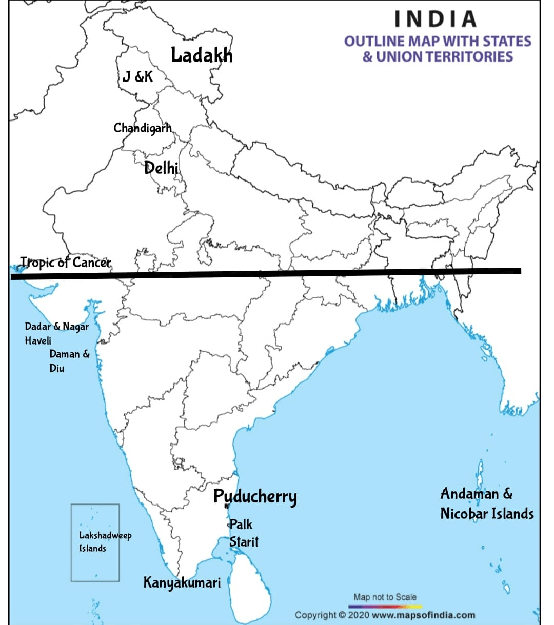
MAP SKILLS
Question 1:Identify the following with the help of map reading.
(i)The island groups of India lying in the Arabian Sea and the Bay of Bengal.
(ii)The countries constituting Indian subcontinent.
(iii)The States through which the Tropic of Cancer passes.
(iv)The northernmost latitude in degrees.
(v)The southernmost latitude of the Indian mainland in degrees.
(vi)The eastern and the western-most longitude in degrees.
(vii)The place situated on the three seas.
(viii)The strait separating Sri Lanka from India.
(ix)The Union Territories of India.
Answers :
(i)Andaman Islands in Bay of Bengal.
Lakshadweep islands in Arabian Sea.
(ii) Indian subcontinent is divided into the countries of India, Pakistan and Bangladesh.
(iii) The Tropic of Cancer passes through eight states in India: Gujarat, Rajasthan, Madhya Pradesh, Chhattisgarh, Jharkhand, West Bengal, Tripura and Mizoram.
(iv) 37°4' N
(v) 8°4' 4
(vi) Easternmost longitude- 97° 25′ E.
western-most longitude - 68∘7'E
(vii) Kanyakumari
(ix) There are 8 Union Territories of India.
- Andaman and Nicobar Islands
- Dadra and Nagar Haveli and Daman and Diu
- Chandigarh
- Lakshadweep
- Puducherry
- Delhi
- Ladakh
- Jammu and Kashmir
PROJECT/ACTIVITY
Question (i):Find out the longitudinal and latitudinal extent of your state.
Answer :Madhya Pradesh is located in the geographic heart of India in between the latitude of 21.6°N–26.30°N and longitude of 74°9'E–82°48'E.
Question (ii):Collect information about the ‘Silk Route’. Also find out the new developments, which are improving communication routes in the regions of high altitude.
Answer :The Silk Route was a historic trade route that dated from the second century B.C. until the 14th century A.D. It stretched from Asia to the Mediterranean, traversing China, India, Persia, Arabia, Greece, and Italy. It was called the Silk Route because of the heavy silk trading that took place during that period.
Recently, several new developments have taken place which are improving communication routes in the regions of high altitude. Now, we have roads and highways. Railway lines are also being laid through bridges, tunnels and caves. Means of communication such as telephones, satellite phones, mobile phones etc. can also be found in the regions of high altitude.
Intext Questions
Question :Why 82°30'E has been selected as the standard Meridian of India?
Answer :Because it passes through the center of India.
Question :Why is the difference between the durations of day and night hardly felt at Kanyakumari but not so in Kashmir?
Answer :Kanyakumari lies near the equator so the day night difference is one hour there and therefore the duration of day and night is hardly felt at Kanyakumari.
Kashmir is 30 degrees away from the equator and so the difference in duration of day and night is more there.
Question :The number of union territories along the western and eastern coasts.
Answer :Daman & Diu and Dadra and Nagar Haveli are located on the western coast.
Puducherry is located on the eastern coast.
Question :Area wise which is the smallest and which is the largest state?
Answer :Goa is the smallest state area wise.
Rajasthan is the largest state area wise.
Question :The states which do not have an international border or lie on the coast.
Answer :Those states are Haryana, M.P., Jharkhand and Chhattisgarh.
Question :Classify the states into four groups each having common frontiers with
(i)Pakistan
(ii)China
(iii)Myanmar
(iv)Bangladesh
Answer :
Pakistan: Jammu & Kashmir, Rajasthan, Punjab and Gujarat.
China: Himachal Pradesh, Jammu & Kashmir, Sikkim, Arunachal Pradesh.
Myanmar: Arunachal Pradesh, Nagaland, Manipur and Mizoram.
Bangladesh: Bihar, West Bengal, Jharkhand, Assam, Meghalaya and Tripura.