Geography - Class 6
The Earth: Our Habitat
Chapter 7: Our Country India
Question 1. Answer the following questions briefly.
- Name the major physical divisions of India.
Answer: The major physical divisions of India are:-
- The Himalayas
- The Northern Indian Plains
- The Peninsular Plateau
- The Coastal Plains
- The Islands
- India shares its land boundaries with seven countries. Name them.
Answer: India shares its land boundaries with seven countries, these are:-
- Pakistan
- Afghanistan
- Nepal
- Bhutan
- Bangladesh
- Myanmar
- China
- Which two major rivers fall into the Arabian Sea?
Answer: The two major rivers that fall into the Arabian sea are:-
- Narmada
- Tapi
- Name the delta formed by the Ganga and the Brahmaputra.
Answer: The Sundarban delta is formed by the Ganga and the Brahmaputra rivers.
- How many States and Union Territories are there in India? Which states have a common capital?
Answer: There are 29 states and 9 union territories in India. Haryana and Punjab have a common capital.
- Why do a large number of people live in the Northern plains?
Answer: A large number of people live in the Northern Plains because:-
- They are generally level and flat.
- These are formed by the alluvial deposits laid down by the rivers.
- These river plains provide fertile land for cultivation.
- Why is Lakshadweep known as a coral island?
Answer: Lakshadweep is known as a coral island because it is formed from corals. Coral are skeletons of tiny marine animals called Polyps.
Do you need help with your Homework? Are you preparing for Exams?
Study without Internet (Offline)
Question 2. Tick the correct answer.
- The southernmost Himalayas are known as
- Shiwaliks
- Himadri
- Himachal
- Sahyadris is also known as
- Aravali
- Western Ghats
- Himadri
- The Palk Strait lies between the countries
- Sri Lanka and Maldives
- India and Sri Lanka
- India and Maldives
- The Indian islands in the Arabian Sea are known as
- Andaman and Nicobar Islands
- Lakshadweep Islands
- Maldives
- The oldest mountain range in India is the
- Aravali hills
- Western ghats
- Himalayas
Answer:
- (i) Shiwalik
- (ii) Western ghats
- (ii) India and Sri Lanka
- (ii) Lakshadweep Islands
- (i) Aravali hills
Question 3. Fill in the blanks.
- India has an area of about ________________.
- The Greater Himalayas are also known as_________________.
- The largest state in India in terms of area is__________________.
- The river Narmada falls into the __________________ sea.
- The latitude that runs almost halfway through India is ___________.
Answer:
- India has an area of about 3.28 million sq. km.
- The greater Himalayas are also known as Himadri.
- The largest state in India in terms of area is Rajasthan.
- The river Narmada falls into the Arabian sea.
- The latitude that runs almost halfway through India is tropic of cancer.
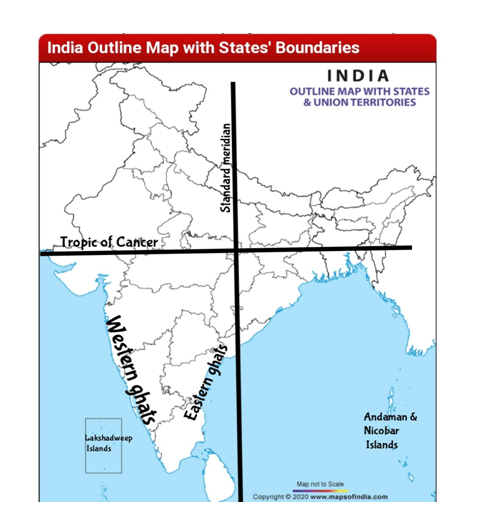
Map Skills
Question: On an outline map of India, mark the following.
- Tropic of Cancer
- Standard Meridian of India
- State in which you live
- Andaman Islands and Lakshadweep Islands
- Western Ghats and Eastern Ghats
Answer:
- The Tropic of Cancer passes through eight states in India: Gujarat, Rajasthan, Madhya Pradesh, Chhattisgarh, Jharkhand, West Bengal, Tripura and Mizoram.
- Standard Meridian of India (82°30'E) passes through Mirzapur (in Uttar Pradesh).
- Western ghats : Kerala, Tamil Nadu, Karnataka, Goa, Maharashtra and Gujarat.
- Eastern ghats : Odisha, Andhra Pradeshto Tamil Nadu in the south passing some parts of Karnataka as well as Telangana.