Geography - Class 6
The Earth: Our Habitat
Chapter 4: Maps
Question 1. Answer the following questions briefly.
- What are the three components of a map?
Answer: The three components of a map are distance, direction & symbol.
- What are the four cardinal directions?
Answer: The four cardinal directions are East West North and South. The other four intermediate directions are North-East, south- east, south-west, and north-west.
- What do you mean by the term ‘the scale of the map’?
Answer: Scale is the ratio between the actual distance on the ground and the distance shown on the map. A small distance on paper represents a large distance on the ground, a scale is chosen for this purpose.
- How are maps more helpful than a globe?
Answer: Maps are more helpful than a globe because we can study any country, state, district, town, and village separately from a map. From a globe, we can study the earth as a whole only.
- Distinguish between a map and a plan.
Answer:
Map Plan A map is a representation or a drawing of the Earth's surface. A plan is a drawing of a small area on a large scale. We can draw things on larger scales. We can draw things on a smaller scale like the length and breadth of a room. - Which map provides detailed information?
Answer: Large scale map provides detailed information.
- How do symbols help in reading maps?
Answer:
- It is not possible to draw the actual shape and size of different features such as buildings, roads, bridges, trees, railway lines, on a map. That's why different symbols are used in their places.
- These symbols give a lot of information in a limited space.
- Maps can be drawn easily and are simple to read.
- Even if you don’t know the language of an area, you can collect information from maps with the help of these symbols.
- Maps have a universal language that can be understood by all.
Question 2. Tick the correct answer.
- Maps showing distribution of forests are
- Physical map
- Thematic Map
- Political map
- The blue colour is used for showing
- Water bodies
- Mountains
- Plains
- A compass is used –
- To show symbols
- To find the main direction
- To measure distance
- A scale is necessary
- For a map
- For a sketch
- For symbols
Answer:
- (ii) Thematic map
- (i)Water bodies
- (ii) To find the main direction
- (i) For a map
Activities:
Question 1. Find out the following directions from the Figure 4.1: (a) The direction of the Community Centre, the playground from Vikas’s house (b) the direction of school from shops.
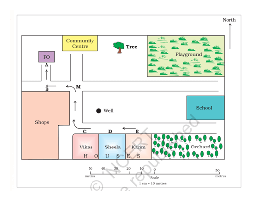
Answer:
- The direction of the Community Centre: North
the playground from Vikas’s house: North-east - The direction of school from shops: East
Question 2. Look at the Figure 4.4 and find out :
- In which direction is the river flowing?
- What kind of road passes by the side of village Dumri?
- On what type of railway line is Sunderpur situated?
- On which side of the railway bridge is the police station situated?
- On which side of the railway line do the following lie :
- Chhatri
- Church
- Pond
- Mosque
- River
- Post and Telegraph Office
- Graveyard
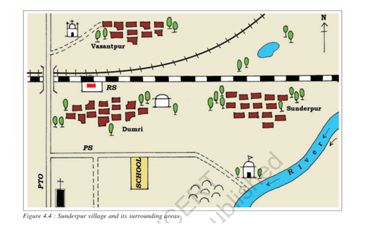
Answer:
- Downwards
- Metalled road
- Broad gauge railway line
- In the south
- Chhatri - south
- Church – south-west
- Pond - north
- Mosque – north-west
- River- south-east
- Post and Telegraph Office – south-west
- Graveyard- south